title: “Swiss Alps Hiking Guide for Beginners 2026: Hidden Trails You Must Try”
slug: “swiss-alps-hiking-guide-beginners-2026”
domain: “switzerlandvibe.com”
primary_keyword: “Swiss Alps hiking guide beginners 2026”
date: 2026-06-18
word_count: 2680
status: draft
schema:
– Article
– FAQPage
– Author
Swiss Alps Hiking Guide for Beginners 2026: Hidden Trails You Must Try

The Swiss Alps are not exclusively for seasoned mountaineers. A well-planned first hike here delivers something most mountain destinations cannot match: cable cars that climb 2,000 metres in 25 minutes, trails graded with Swiss precision, and valley views that stop you cold mid-step.
This guide gives you the exact trails, logistics, and gear to hike confidently in Switzerland as a beginner in 2026, including hidden routes that most travel sites skip entirely.
Understanding Swiss Trail Grades Before You Go
Every Swiss trail uses the SAC scale (Swiss Alpine Club), a standardised grading system that removes the guesswork.
For beginners, two grades apply:
| Grade | Colour | What it Means |
|---|---|---|
| T1 | Yellow | Clearly marked paths, gentle gradients. No technical skill needed. |
| T2 | White-red-white | Slightly steeper, some uneven ground. Suitable for fit beginners with basic hiking shoes. |
Avoid T3 and above on a first trip. T3 involves exposed sections and requires sure-footed scrambling. The Swiss Alpine Club publishes grade descriptions at sac-cas.ch, worth bookmarking before you plan.
A critical advantage in Switzerland: lifts and trains access altitude. You do not need to earn every metre on foot. This fundamentally changes what a beginner can experience.
Best Beginner Hikes in the Interlaken Region
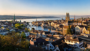
Interlaken sits between two lakes at 568 metres and acts as the gateway to the Bernese Oberland. Train connections from Zurich take around two hours. From Interlaken, you reach Grindelwald in 40 minutes by rail.
Männlichen to Kleine Scheidegg (Panoramaweg)
This is the best first alpine hike in Switzerland. Full stop.
Take the cable car from Grindelwald-Grund to Männlichen (2,342 m). From there, a wide, well-marked path descends gently to Kleine Scheidegg over approximately 4.5 km. The Eiger north face sits directly ahead the entire walk. The Mönch and Jungfrau frame it on either side.
- Grade: T1
- Duration: 1.5 hours one way
- Elevation change: -365 m descent
- Return: Train from Kleine Scheidegg to Grindelwald (approx. CHF 12, covered by Swiss Pass)
No steep sections. No loose scree. The path is wide enough for pushchairs on most sections. AllTrails rates this as one of the top 10 walks in Switzerland (alltrails.com).
Bachalpsee from Grindelwald First
Grindelwald First gondola (25 minutes from Grindelwald village) deposits you at 2,168 m. From the top station, a 1-hour trail leads to Bachalpsee, a glacial lake at 2,265 m surrounded by moorland. The lake reflects the peaks of Schreckhorn and Wetterhorn on calm mornings.
- Grade: T2 (mostly flat with minor undulation)
- Duration: 2 hours return
- Gondola cost: CHF 38 one way from Grindelwald (Swiss Pass gives 50% discount)
The First Cliff Walk near the gondola station is also worth 20 minutes: a steel walkway bolted to the cliff face, no climbing required, with vertiginous views down to Grindelwald.
Lauterbrunnen Valley Floor Walk
If you want to reset expectations of what alpine terrain looks like, walk the Lauterbrunnen valley floor. The trail follows the valley from Lauterbrunnen village to Stechelberg along a flat, 5 km path. Staubbach Falls, Europe’s highest free-falling waterfall at 297 m, drops directly into the village.
- Grade: T1
- Duration: 1.5 hours one way
- Best for: Families, those recovering from jet lag, or anyone who wants the scenery without the climbing
This is the valley where Tolkien reportedly found his visual inspiration for Rivendell. The geology alone justifies the walk.
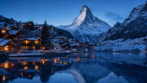
Best Beginner Hikes in the Zermatt Region

Zermatt sits at 1,608 m and is car-free, which keeps the air clear and the streets navigable. The Matterhorn (4,478 m) dominates the view from almost every trail.
Riffelsee Trail from Rotenboden
Take the Gornergrat Railway from Zermatt to Rotenboden station (3,089 m) and walk 30 minutes downhill to Riffelsee. On a clear morning, the Matterhorn reflects perfectly in the lake. This is the most photographed shot in Swiss hiking.
- Grade: T1 (entirely downhill on a good path)
- Duration: 1 hour from Rotenboden to Riffelberg
- Train cost: CHF 47 return to Rotenboden (Swiss Pass 50% discount; Rail Europe sells this in advance)
- Continue to: Riffelberg station to catch the Gornergrat train down, or walk the extra 30 minutes to Riffelalp
This trail is suitable for children. The Gornergrat Railway operates year-round and is one of the highest open-air cog railways in Europe (gornergrat.ch).
Five Lakes Walk (Fünfseenweg)
A longer circuit (10 km, 3-4 hours) connecting five alpine lakes: Stellisee, Grindjisee, Grünsee, Moosjisee, and Leisee. Each lake frames the Matterhorn differently, making this a photographer’s route as much as a hiking one.
- Grade: T2
- Start point: Blauherd station (cable car from Zermatt, approx. CHF 30 one way)
- Best season: July to early October
The elevation gain is minimal because cable cars do the hard work. Most beginners complete this comfortably in half a day.
Hidden Trails Worth Finding
Most guides stop at Zermatt and Interlaken. These three less-known options are worth the extra logistics.
Mürren to Grütschalp (Bernese Oberland)
Mürren is a car-free village perched at 1,638 m above the Lauterbrunnen valley. It is accessible only by cable car from Stechelberg or by funicular from Lauterbrunnen. This isolation keeps crowds lower than Grindelwald.
The trail from Mürren to Grütschalp runs mostly flat along the cliff edge, with the Lauterbrunnen valley 800 m below on one side and the Eiger, Mönch, and Jungfrau ahead. Distance: 7 km. Duration: 1 hour 40 minutes. Grade: T1.
From Grütschalp, a narrow-gauge train runs to Lauterbrunnen in 30 minutes. The entire circuit requires no trekking experience, just a reasonable fitness level.
Sigriswil Ridge Walk (Bernese Mittelland)
Forty minutes from Interlaken by car or 1 hour by regional bus, Sigriswil sits above Lake Thun at around 900 m. The panorama bridge spanning the gorge between Sigriswil and Tschingeloch is one of the most underrated viewpoints in the country, 182 m above the gorge floor, 340 m long.
The ridge walk from Sigriswil to Aeschried is 6 km with minimal elevation change. You see Lake Thun, the Bernese Alps, and on clear days, as far as the Valais 4,000 m peaks.
This is a genuine local secret. No cable cars required, no tourist crowds.
Melchsee-Frutt Circular, Obwalden
Two hours from Zurich by car (or train to Lungern then PostBus), Melchsee-Frutt sits at 1,920 m on a high plateau above the Obwald canton. The Four Alpine Lakes Route here, Trübsee, Engstlensee, Tannensee, and Melchsee, links four lakes across 14 km of mostly T1 and T2 terrain.
This area draws almost no international visitors yet delivers panoramic views directly comparable to the Bernese Oberland. In September, the larch trees begin to turn gold and the light quality shifts in a way that is specific to Swiss alpine autumn.
When to Hike: A Practical Seasonal View
| Month | Conditions | Best Areas |
|---|---|---|
| Late May – June | Trails opening, some snow above 2,000 m | Valley walks, Zermatt lower trails |
| July – August | Full access, busiest crowds, afternoon storms | All regions, start hikes early |
| September | Best light, thinner crowds, larch colours begin | Graubünden, Obwalden, Valais |
| October | Many cable cars close, paths quieter | Low-altitude valley walks only |
Afternoon thunderstorms above 2,000 m are routine from July to August, not exceptional. SRF Meteo (meteo.srf.ch) provides detailed alpine forecasts by altitude zone. Check it each morning.
Temperature drops approximately 1°C per 100 metres of altitude gain. A warm day in Interlaken at 22°C means the Männlichen ridge at 2,300 m sits at around 8°C with wind.
What to Pack: The Non-Negotiable List

Swiss alpine terrain punishes underpacking more than most mountain environments because weather changes fast and rescue in remote areas is expensive.
Footwear: Stiff-soled hiking boots with ankle support. For T1 trails, trail runners work. For T2 with any descent, ankle support matters.
Layers:
1. Moisture-wicking base layer (merino or synthetic)
2. Fleece or insulated mid-layer
3. Waterproof outer shell (Gore-Tex or equivalent)
Pack (18-25 L) contents:
– 1.5-2 L of water per person
– High-energy snacks (mountain huts sell food but add CHF 15-25 per person)
– Offline maps downloaded via AllTrails or Swisstopo app
– Sunscreen SPF 50 (UV radiation is 25-35% stronger at altitude)
– Sunglasses with UV protection
– Emergency foil blanket
– First aid basics
The Swisstopo app (Swiss Federal Office of Topography) provides the most accurate trail maps available, with offline function. Free for basic use.
Getting to the Trailheads Without a Car
Switzerland’s rail network handles most of this automatically.
Interlaken access:
– Zurich HB to Interlaken Ost: 2 hours, every 30 minutes, from CHF 52 (advance), fully covered by Swiss Pass
Zermatt access:
– Zurich to Zermatt: 3 hours 15 minutes via Visp, covered by Swiss Pass. No cars enter Zermatt, trains are the only option.
Swiss Pass: If you plan three or more days of train travel, calculate whether the Swiss Pass saves money. A 3-day Flex Swiss Pass starts at CHF 232 (adult, 2nd class) and covers national trains plus 50% discount on most mountain railways. Rail Europe sells these with advance booking options.
For your travel planning across the region, check the Best Swiss Train Routes 2026 guide for full route breakdowns and schedule logic.
Where to Stay: Mountain Hotels for Beginners
Staying close to the trailhead makes early starts practical and eliminates transport stress on hiking days.
Our Top Pick: Trip.com for Swiss Mountain Hotels
For finding the right hotel at the right altitude, whether that is a guesthouse in Grindelwald, a family hotel in Zermatt, or a quiet property above Interlaken, Trip.com covers the full Swiss inventory with competitive rates and flexible cancellation options that matter when weather determines your plans.
Why Trip.com works for Swiss hiking trips:
– Wide selection of properties in smaller alpine villages (not just major cities)
– Instant confirmation on most Swiss mountain hotels
– Flexible cancellation policies, useful when weather forecasts change your dates
– Competitive pricing on peak summer bookings in Zermatt and Interlaken
Book your Swiss Alps hotel via Trip.com: Find mountain hotels in Switzerland
Recommended Base Locations by Region
Grindelwald: Ideal for Männlichen, Bachalpsee, and Kleine Scheidegg. Mid-range hotels run CHF 150-250 per night in July. Book 8-10 weeks in advance for summer.
Zermatt: Higher price point (CHF 200-400 mid-range), but the car-free atmosphere and direct gondola access from the village justify the premium. Search via Trip.com to compare across the full hotel inventory.
Mürren: For those wanting fewer crowds. Accommodation is limited (20-30 properties in the village), so early booking is essential. A quiet choice for anyone doing the Mürren to Grütschalp trail.
Interlaken: If you want a more urban base with day-trip access to multiple regions, Interlaken’s hotel supply is larger and pricing is lower. CHF 100-180 per night for solid three-star options.
If you need a broader Switzerland accommodation context alongside your hiking plan, the Switzerland 7-Day Itinerary covers multi-city logistics including where to stay per night.
For Zurich-based stays before or after your hiking trip, the Best Hotels in Zurich for Tourists guide has vetted options across price brackets.
Alternative Booking Option
Booking.com is a strong alternative with a large Swiss inventory and a well-known loyalty programme. Trip.com typically offers slightly better rates on smaller alpine guesthouses and more rural properties.
Safety on Alpine Trails: What Beginners Miss
Three things new hikers consistently underestimate in the Swiss Alps:
1. Weather moves faster than the forecast. Check the forecast at the exact altitude of your trail, not the valley. At 2,000 m+, calm mornings can transition to electrical storms in 90 minutes during July and August. Start hikes before 9 am when possible.
2. Sun at altitude is severe. At 2,500 m, UV radiation is significantly stronger than at sea level. Sunburn through cloud is common. Use SPF 50 and reapply every two hours.
3. Descent is harder than ascent. Most trail accidents in the Alps happen on descent, not ascent. Trekking poles reduce knee strain significantly on long downhills. Rent them in Grindelwald or Zermatt if you do not own a pair (CHF 10-15 per day from most outdoor shops).
The Swiss rescue service (Rega) operates helicopter rescue across Switzerland. Travel insurance covering mountain rescue is standard for alpine visitors, confirm your policy before departure.
Frequently Asked Questions
Do I need hiking boots for Swiss Alps trails rated T1?
For T1 trails in dry summer conditions, trail runners or supportive walking shoes are adequate. Hiking boots become important on T2 trails and any trail where descent is steep or surfaces are wet. When in doubt, boots with ankle support are the safer choice.
What is the best Swiss Alps region for a first-time hiker?
The Interlaken and Grindelwald region (Bernese Oberland) offers the best combination of accessible trail grades, cable car infrastructure, and beginner-friendly logistics. The Männlichen to Kleine Scheidegg walk is the single best first-time choice.
Is the Swiss Pass worth it for a hiking trip?
If you plan to use trains for four or more travel days, including day trips from a base, the Swiss Pass typically saves money versus point-to-point tickets. The 50% discount on mountain railways (gondolas, cog trains) adds substantial value specific to hiking trips.
When do Swiss Alps trails open after winter?
Lower trails at village altitude open by May. Trails above 2,000 m typically open between mid-June and early July, depending on snowpack. Check SchweizMobil for live trail condition updates before your trip.
Can I hike in the Swiss Alps without a guide?
Yes. T1 and T2 trails are fully self-guided with clear yellow waymarking throughout. Trail signs display destination, estimated duration, and difficulty. For T3 and above, or if you want to explore less-marked terrain, hiring a certified guide through a local alpine club adds meaningful safety margin.
Final Planning Checklist
- Download Swisstopo app with offline maps for your target region
- Check SRF Meteo each morning for altitude-specific forecasts
- Book accommodation early for July and August (Zermatt, Grindelwald, Mürren sell out 8+ weeks ahead)
- Confirm Swiss Pass or point-to-point tickets before arrival
- Pack the three-layer system regardless of the forecast
- Start hikes before 9 am in summer to avoid afternoon storms above 2,000 m
Switzerland rewards hikers who plan precisely. The trails are there, the infrastructure is exceptional, and the scenery is not exaggerated by tourism boards. Plan well, start early, and you will understand why people come back every year.
Ready to book your stay near the trailhead? Find Swiss Alps hotels on Trip.com, filter by mountain location, check flexible cancellation, and book before summer dates fill.
Editorial standards
Why trust this guide
- Route-checked. Itineraries, transfers and timings are verified against current public-transport schedules and operator pages.
- Honest comparisons. Hotel areas and tours are compared on real value — affiliate links never change the recommendation.
- Transparent. Some links are affiliate links; the disclosure is shown on every guide.
This guide is informational travel content, not professional travel, financial or legal advice. Always confirm prices, opening times and conditions with the official provider before you book.