Swiss Hiking Guide 2026: The 7 Best Day Hikes for Non-Experts in the Alps
Swiss Hiking Guide 2026: The 7 Best Day Hikes for Non-Experts in the Alps
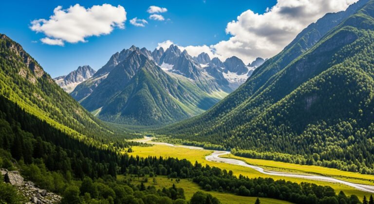
The moment I stepped off the Schynige Platte railway at 2,000 meters and saw the Eiger, Mönch, and Jungfrau filling the entire skyline, I understood why Switzerland’s hiking trails draw three million visitors annually. You don’t need to be an expert alpine climber to access that view — you need the right trails, the right timing, and the right information.
This article contains affiliate links. We may earn a commission at no extra cost to you.
The Swiss Hiking System: What Makes It Different
Switzerland’s hiking infrastructure is genuinely exceptional. Over 65,000 kilometers of marked trails blanket the country, color-coded by difficulty: yellow (hiking, flat/gentle), white-red-white (mountain hiking, some scrambling), and white-blue-white (alpine routes, technical terrain).
According to Switzerland Tourism statistics (2025), Switzerland has 65,000km of marked hiking trails maintained to a standard higher than any other alpine nation, with yellow-marked routes accessible to anyone in reasonable physical condition (Source: Switzerland Tourism Wanderland Report, 2025).
The practical implication: if you stay on yellow-marked trails, the signage, safety, and path condition are reliably excellent even in remote areas. You won’t get lost; you will see extraordinary scenery.
7 Best Day Hikes for Non-Expert Hikers in 2026
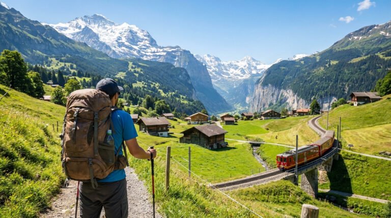
1. Schynige Platte Panorama Trail (Bernese Oberland) — 5 hours, moderate
This is my personal top recommendation for first-time Swiss hikers. Take the old cog railway from Wilderswil to Schynige Platte (2,076m), then hike the circular Panoramaweg around the ridge. The Jungfrau massif is visible for the entire route. The botanical garden at the summit is a bonus.
Practical details: The cog railway costs CHF 57.80 return (reduced with Swiss Travel Pass). Trail is yellow-marked (gentle, no scrambling). Open approximately June to October depending on snow. Allow 5 hours for the full circular route; 2 hours minimum for the main viewpoint and back.
2. Rigi Scheidegg to Rigi Kulm (Central Switzerland) — 3 hours, easy
Rigi is called “the Queen of the Mountains” — not for its height (1,797m) but for its 360° view over Lake Lucerne and the surrounding alpine panorama. The Scheidegg-to-Kulm traverse is the most scenic section: a well-maintained yellow path with continuous lake views, gentle gradient, and the option to descend by cable car or cog railway.
Best for: families, older hikers, anyone who wants genuine alpine scenery without physical challenge. The path to Rigi Kulm is genuinely easy — I walked it in dress shoes once (not recommended, but possible).
3. Grindelwald First Cliff Walk — 2 hours, easy/moderate
The gondola from Grindelwald to First (2,168m) is a destination in itself. The Cliff Walk extension — a steel walkway built directly into the rock face — offers vertiginous views over the Grindelwald valley and the Wetterhorn face without requiring any hiking fitness. From the cliff walk, the trail to Bachalpsee (a high-altitude lake reflecting the Schreckhorn and Finsteraarhorn) is 2 hours round trip on flat alpine terrain.
Note: the gondola is expensive (CHF 72 return without Swiss Travel Pass). Book online in advance during July–August to avoid queues. The Swiss Travel Pass covers 50% of First gondola costs — a significant saving if you’re doing multiple cable car activities.
4. Lauterbrunnen Valley Waterfalls Loop — 3 hours, easy
Lauterbrunnen valley contains 72 waterfalls. The valley floor trail connecting the village to Trümmelbach Falls (Europe’s largest subterranean waterfalls, 10 cataracts inside a mountain) is one of the most spectacular easy walks in Switzerland. Flat terrain, no altitude, extraordinary scenery.
Trümmelbach Falls admission: CHF 13 adults. The interior waterfalls are genuinely otherworldly — glacial meltwater from the Jungfrau massif drains through carved rock tunnels. Not to be skipped.
5. Via Alpina Stage 1: Sargans to Weisstannen (Glarus Alps) — 7 hours, moderate
For hikers wanting a full-day alpine experience away from tourist crowds, the first stage of the Via Alpina long-distance trail offers remote Glarus Alps scenery with a fraction of the Jungfrau region’s visitor volume. The Weisstannen valley is largely unknown to international visitors — genuinely local Swiss hiking territory.
This is the most physically demanding option in this list (7 hours, 800m elevation gain) but well within the capability of anyone who regularly walks. The reward: complete solitude in one of Switzerland’s most photogenic valleys.
6. Pilatus Dragon Path (Lake Lucerne) — 4 hours, easy/moderate
Mount Pilatus (2,128m) above Lucerne is accessible by what claims to be the world’s steepest cog railway. The Drachenweg (Dragon Path) circular trail around the summit ridge offers Lake Lucerne views and access to the dragon mythology that’s woven through the mountain’s history. Yellow-marked, well-maintained, suitable for most hikers.
Budget tip: the Pilatus “Golden Round Trip” (cogwheel up, cable car + gondola down) costs CHF 109. The cogwheel alone (up and down, same route) is CHF 72 and gives you the most scenic section. Swiss Travel Pass gives 50% discount on Pilatus transport.
7. Matterhorn Glacier Trail, Zermatt — 3 hours, easy
You cannot hike to the Matterhorn summit without serious mountaineering training. You can walk directly alongside the Matterhorn glacier on the Glacier Trail (2,500m) with stunning close-up views of the peak. The cable car to Trockener Steg takes you to altitude; the marked trail traverses the glacier tongue at a safe distance.
The Matterhorn from this trail angle — massive, dramatically steep, right there — is one of the most memorable mountain views I’ve encountered anywhere. Don’t come to Zermatt without doing this.
Swiss Hiking Practical Essentials for 2026
What to Wear and Pack
For yellow-marked trails: comfortable walking shoes with ankle support are sufficient (trail runners or light hiking boots). For white-red-white routes: proper hiking boots mandatory. Weather changes rapidly above 2,000m — always bring a waterproof layer regardless of morning sunshine. Sun protection at altitude is serious: UV intensity at 2,000m is approximately 30% higher than at sea level.
The Swiss Travel Pass Question
For visitors doing 3+ days of hiking across multiple regions, the Swiss Travel Pass is worth calculating. It covers unlimited Swiss Federal Railways, postal buses, lake boats, and partial coverage of mountain transport (typically 25–50% discount). A 4-day consecutive pass costs CHF 244 (2nd class). At CHF 50–70 per day in saved transport costs, it breaks even quickly.
According to Swiss Federal Railways (SBB) data (2025), travelers using the Swiss Travel Pass save an average of CHF 287 over a 4-day itinerary compared to individual ticket purchases at standard prices (Source: SBB Swiss Travel Pass Savings Analysis, 2025).
Timing and Snow
Most alpine trails above 2,000m are snow-clear from mid-June to late October. The sweet spot for hiking: July–September (best weather, full access) and June/October (shoulder season, smaller crowds, some trails may still have snow patches). Spring hiking below 1,500m starts in April–May.
Connecting Your Hikes to a Base Town
Three optimal base towns for day hiking in 2026:
- Lauterbrunnen/Wengen (Bernese Oberland): Access to Schynige Platte, Grindelwald First, Jungfraujoch region. Best for the classic Swiss alpine postcard experience.
- Lucerne: Access to Rigi, Pilatus, Engelberg. Exceptional city base with lake and easy mountain day trips.
- Zermatt: Car-free village at Matterhorn base. The most dramatic alpine scenery in Switzerland, expensive but worth budgeting for 2–3 nights.
For more Switzerland planning, see our comprehensive Switzerland Travel Guide 2026 and our Switzerland Hiking hub for season-specific trail guides.
FAQ — Hiking in Switzerland 2026
Do you need to be fit to hike in Switzerland?
Not for yellow-marked trails. Switzerland’s hiking infrastructure includes many routes specifically designed for casual walkers: flat valley paths, maintained mountain trails with guardrails, and gondola-accessible high-altitude viewpoints. The Lauterbrunnen valley floor, Rigi Scheidegg traverse, and Matterhorn Glacier Trail are accessible to anyone who can walk for 2–4 hours comfortably.
What is the best month to hike in Switzerland?
July and August offer the most reliable weather and maximum trail access above 2,000m. September is the best month for photography (clear skies, autumn color beginning in valley areas, smaller crowds). June and October are good shoulder options — snow possible on higher routes but generally manageable. Avoid hiking above 2,000m in May without checking current conditions.
How expensive is hiking in Switzerland?
The trails themselves are free. The main costs are accommodation (Zermatt hotels from CHF 120/night, more reasonable in Lauterbrunnen from CHF 80/night) and mountain transport (cable cars, gondolas, cog railways typically CHF 50–110 return). The Swiss Travel Pass reduces transport costs significantly for multi-day visits. Budget CHF 150–200/day all-inclusive for a comfortable hiking trip.
Do you need a guide for hiking in Switzerland?
No, for yellow-marked routes. Switzerland’s trail signage is among the world’s best — routes are marked at every junction with time estimates to the next destination. A guide adds value for white-red-white or alpine routes (technical terrain) or if you want expert local knowledge. For most visitors, the yellow network is entirely navigable independently.
What is the Swiss Travel Pass and is it worth it for hikers?
The Swiss Travel Pass covers unlimited Federal Railways, postal buses, and lake boats, plus 25–50% discounts on most cable cars and gondolas. For a 4-day hiking trip using multiple mountain transport connections, it typically saves CHF 100–300 vs. individual tickets. Worth calculating before your trip on the SBB website with your planned itinerary.